Range & Wildlife Division

The Range and Wildlife Division (RWD) was established in 2001 and is tasked with identifying, developing, and implementing projects and management practices that benefit approximately 141,000 acres of the Pueblo’s uplands and the people, wildlife and livestock that depend on them. The RWD includes nine full time employees who are responsible for implementing projects such as the Upland Vegetation Assessment and Strategic Management Plan Development Project, the Rio Jemez Corridor Conservation Project, the Oneseed Juniper Density Reduction Project, the Santa Ana Mesa Environmental Quality Incentives Project, the Wild Turkey Reintroduction Project, the Pronghorn Reintroduction project, the Mule deer and elk Management Projects, the Large Predator Monitoring Project, and Surveying and Monitoring Southwestern Willow Flycatchers and Yellow-billed Cuckoos. 

The department also collects and analyzes weather data from across the uplands to assist with landscape and wildlife management projects. This data is collected at a number of locations and through a variety of methods across the Pueblo and is essential for tracking long-term climate trends and how it impacts plant and wildlife communities on the Pueblo.

In addition, the Pueblo has been working to address wildlife connectivity issues by studying which paths large mammals use as they move across the landscape throughout the year to find food, mate, migrate, or disperse; and working to identify where some of those traditional routes have been narrowed or blocked by roads, development, or other land-use changes; and to protect the wildlife corridors that are still functioning today.

Collaborators and partners in implementing these projects include the United States Environmental Protection Agency (USEPA), the United States Fish and Wildlife Service (USFWS), the United States Army Corps of Engineers (USACE), the Natural Resources Conservation Service (NRCS), the Bureau of Indian Affairs (BIA), the United States Forest Service (USFS), the University of New Mexico Museum of Southwestern Biology (MSB), the National Wild Turkey Federation (NWTF), and the New Mexico Department of Game and Fish (NMGF)


Rangeland Weather Data

Introduction and Background  

Collecting and recording weather data serves as a crucial first step understanding and tracking climate conditions. The climate influences and impact all aspects of our lives, from droughts and flooding, to heat waves and cold snaps. Recording weather data is essential for tracking long-term climate trends. By collecting this data over extended periods of time, you can begin to identify patterns and track changes in weather conditions. This data is vitality important in accessing changes to the local climate, and its impacts on ecosystems and landscape health. The Pueblo uses this data to inform rangeland and wildlife management decisions and formulate strategies for adaptation and mitigation.  

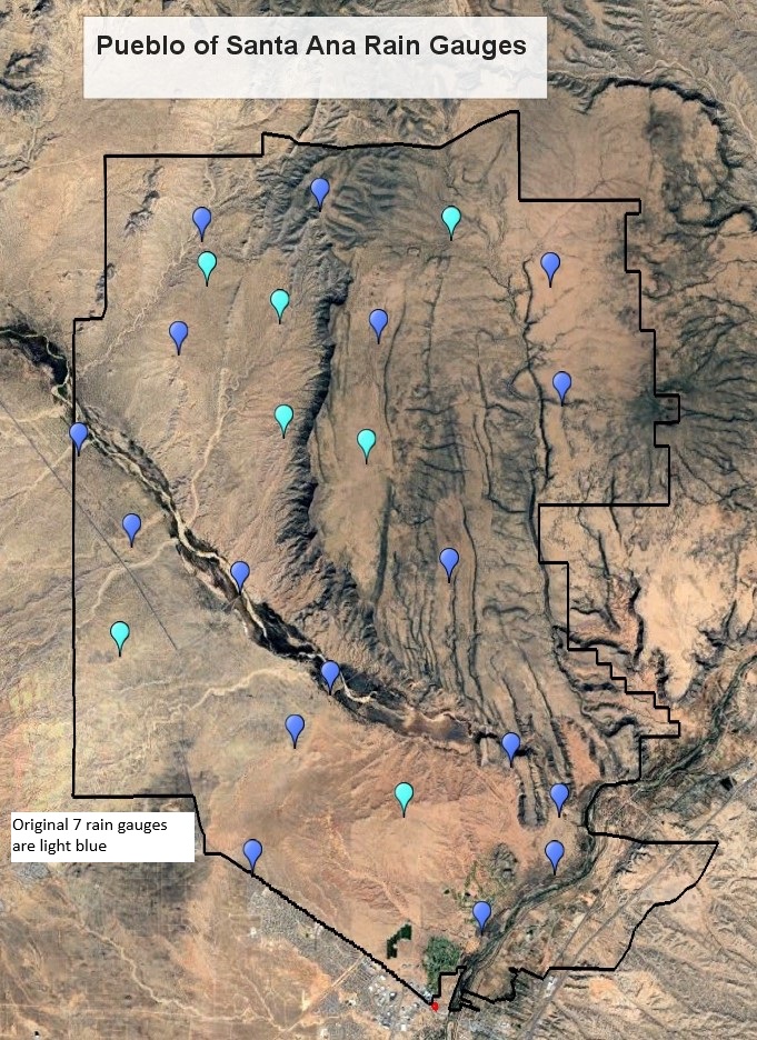
  • The Range and Wildlife Division has been collecting data on precipitation since 2000
  • The Division started with 7 rain gauges back in 2000 and has been gradually putting in additional rain gauges to better capture and track precipitation patterns across the landscape. There are now 24 rain gauges spread across the landscape. 
  • The data is used by the Pueblo to track precipitation trends across years and within years. 
  • The data is used to help inform and guide management decisions and goals.  

Tracking Yearly Precipitation on Santa Ana Pueblo 

The graph below shows the yearly precipitation departures of the Pueblo’s data from 2000-2024. 

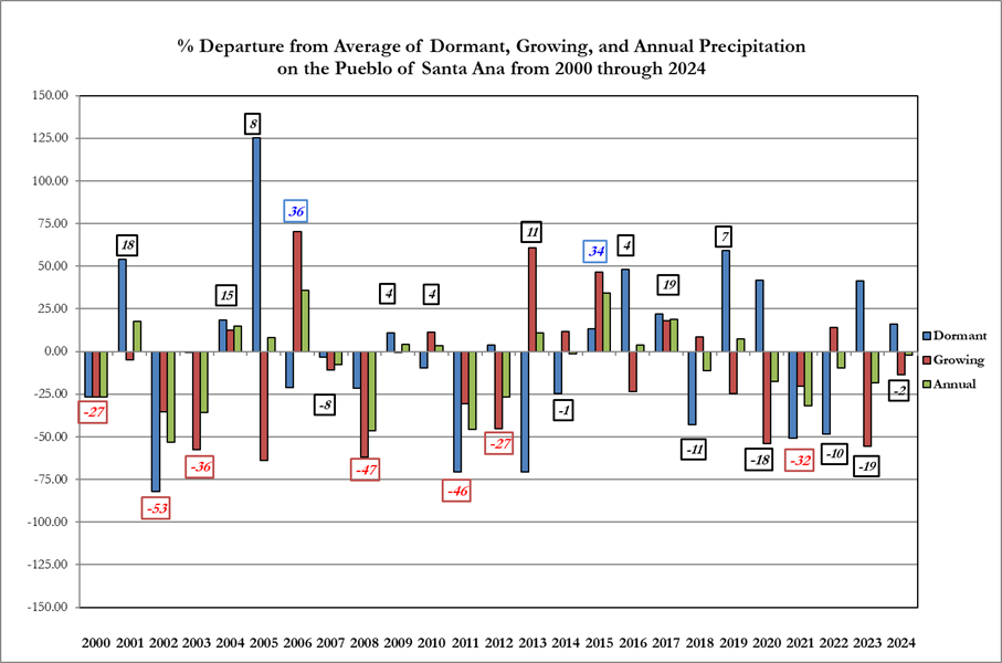
The zero line on the graph above is from a long-term data set collected at a site in Bernalillo NM (1924-1982). This long-term 58-year data set encompasses both drought and wet periods and provides a solid foundational baseline of past precipitation patterns. In the graph above the Pueblo’s data are represented by the colored bars either above or below the zero line. If the precipitation for the year is above the zero-line, it is considered a positive departure from the long term and if it is below the zero-line it is considered a negative departure from the long-term average. Averages -25% or below are considered a drought year and averages 25% or above zero are considered a wet year. 

The Range and Wildlife Division tracks precipitation across a water year which is more ecologically relevant when your thinking about plant communities. The water year runs from October 1st-September 30th and is broken into two 6 months seasons, the Dormant season (Oct 1st-March 31) and the Growing season (April 1-September 30). 

Dormant Season Averages are represented by the blue bar (October 1-March 31), Growing Season Averages are represented by the red bar (April 1-September 30), and Annual Water Year average is represented by the green bar (October 1-September 30). 

Tracking yearly rainfall across the Pueblo allows the department to capture trends in yearly weather patterns. For example, looking at the data above we can see that the trend has been towards drier conditions over the last two and half decades with a larger number of drought years than of wet years. The Pueblo is in the middle of a megadrought that has enveloped the southwest for the last two and a half decades.  

Isocline Maps-Tracking Between and Within Year Variation on the Pueblo of Santa Ana

We also use isocline maps to track precipitation patterns across the Pueblo. For those folks living in the southwest you know how variable precipitation can be across the state. We use this data to help us keep track, analyze and report annual rainfall patterns.  

What are isocline maps?  They mapping tools used to help with interpretation and are an essential tool for conveying complex information in a clear and visually appealing manner. Isocline maps help the reader to understand and recognize connections between data points and the geography of an area. Isocline maps help us to visualize where precipitation occurred on the landscape and make informed management choices. 

The isocline maps (2020-2022) below show the average precipitation value for the year at the Pueblo’s 24 rain gauges. Similar average values are linked by contour lines. The maps illustrate the highly variable precipitation patterns across the Pueblo’s lands.  For example, if you look more closely at the 2021 and 2022 maps you can see that the southern portion of Santa Ana’s lands received about 3 to 4 inches less than the northern portions of the Pueblo.  

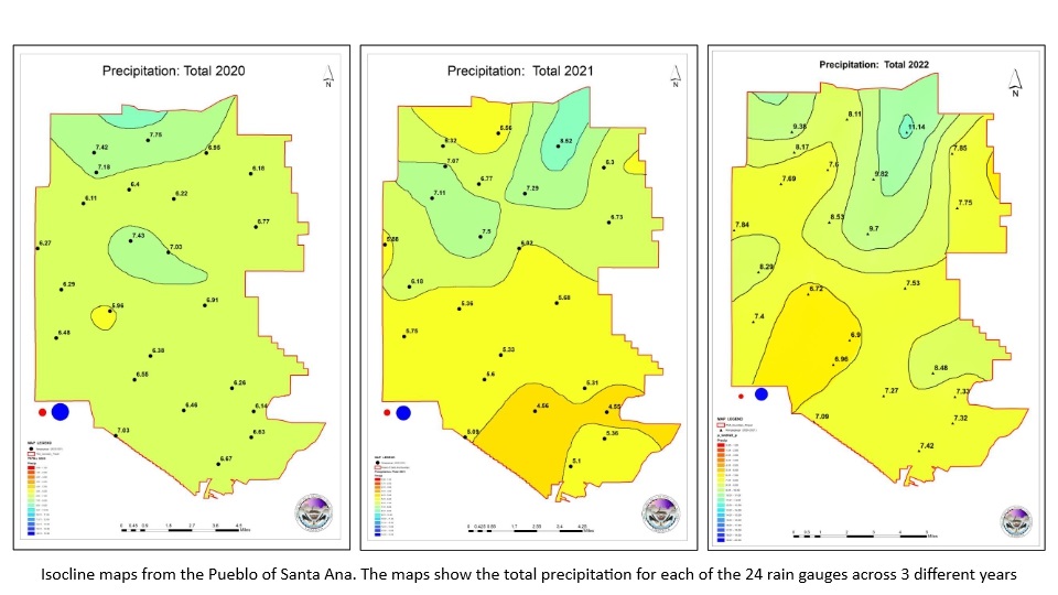
Real Time Weather Data on the Rangeland  

The DNR partnered with the folks from New Mexico Climate Center to install 2 real time data collection weather stations on Santa Ana. These stations are part of a larger meta-network of stations run by the New Mexico Climate Center called the ZiaMet Weather Station Network. The two stations located on the Pueblo began transmitting real-time metrological data during the first weeks of March 2025. 

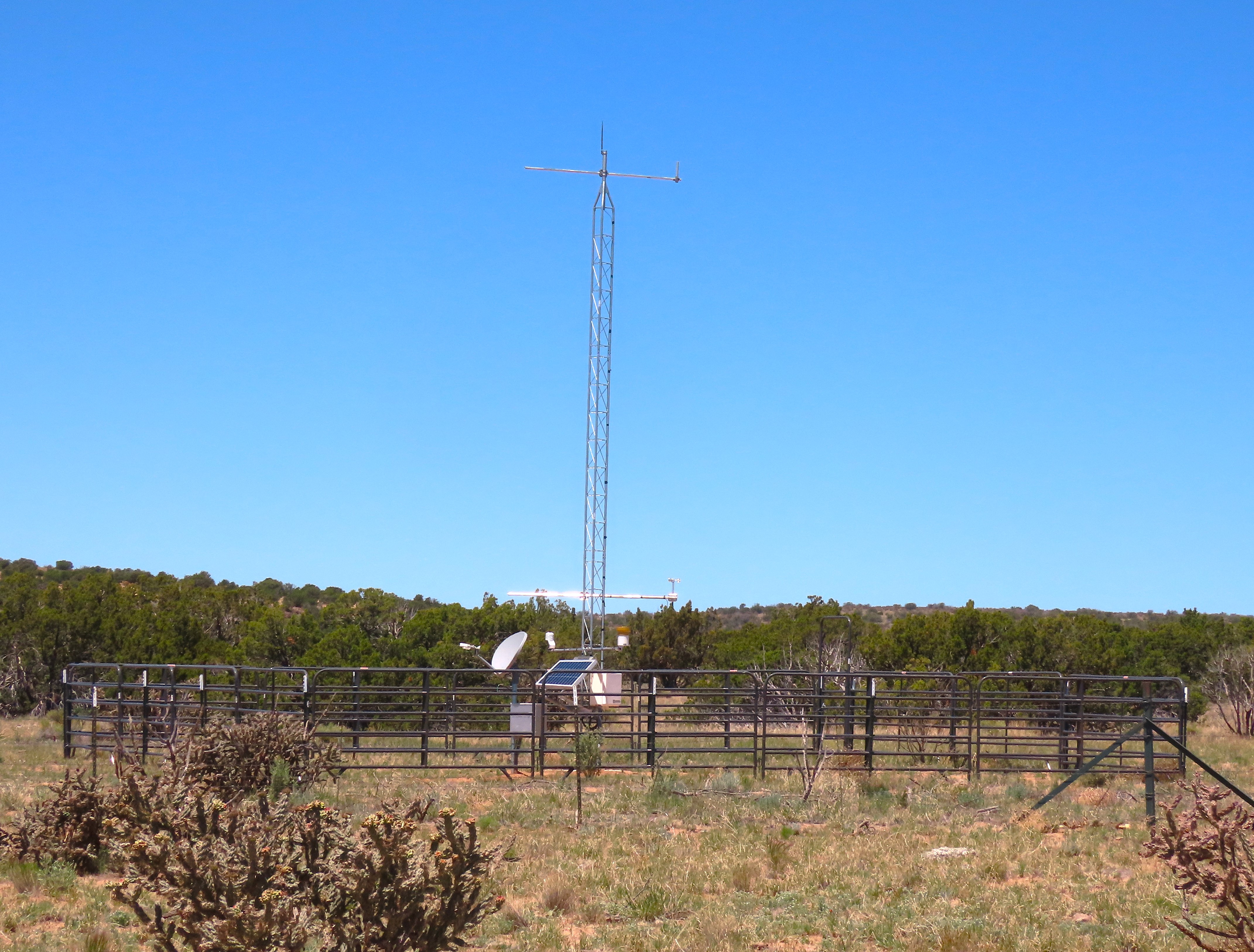
These weather stations (see the Tier 1 schematic and tower photo below) collect data at five-minute intervals are accessible by the public.     

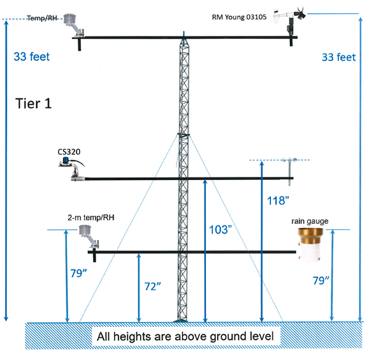
The tier 1 stations collect data on air temperature, dew point, windchill, relative humidity, wind speed, wind direction, solar radiation, and precipitation with a tipping bucket. 

When we were deciding on the locations for the stations we wanted to try and capture as much of the variation across the land as possible. The “Pueblo of Santa Ana” station is located on the mesa in the North central part of the Pueblo and the “Jemez Canyon Reservoir” station is located in the central part of the Pueblo in the foothills near the Jemez weir.

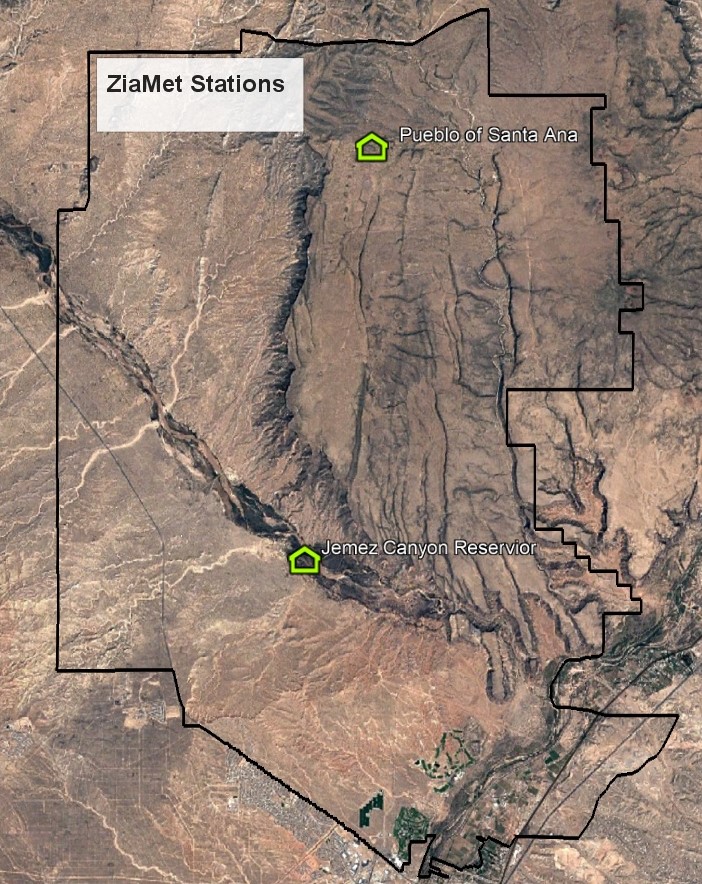
If you are searching for the weather stations on the ZiaMet Weather Station Network website the weather station near the Jemez weir is referred to as “Jemez Canyon Reservoir” and the station on the mesa is referred to as “Pueblo of Santa Ana”. See the attached map above with the location of the stations on Santa Ana. We will be partnering with the climate center in the future to add two more weather stations out at Tamaya Kwe Kee Nee Puu. 

You can access the ZiaMet Weather Station Network site below by selecting a station and clicking on it to get real-time data, as well you can request historical data from the website by clicking the data request button for each station, for example if you wanted additional data for the “Santa Ana Station” you would click the “Data Request Form” button under the Santa Ana Station.

ZiaMet Weather Station Network

ZiaMet Current Conditions

Showing


Upland Vegetation and Grazing Management Practices

Upland Vegetation and Strategic Management Plan 

The RWD conducted an upland vegetation assessment to understand the current conditions associated with the Pueblo’s upland habitats and to understand the spatial and temporal characteristics of vegetation patterns and soil erosion and water infiltration rates on the Pueblo. The project was funded over a four year (1999-2002) period by both the USEPA and the Pueblo. The upland vegetation assessment resulted in: 1) the establishment of 145 permanent upland vegetation and erosion monitoring plots; 2) the characterization and mapping of twenty-two plant associations that cumulatively included two hundred and twenty-five plant species; and 3) the development of a herbarium that includes over 300 plant vouchers.

Information derived from the upland vegetation assessment was used by the RWD to develop a strategic upland vegetation management plan that prioritizes plant association management and defines management practices that will improve the quality and condition of these associations. This ecosystem approach to managing land insures the sustainability of available quality habitats for current and future generations. Management practices identified within the Pueblo’s upland vegetation strategic management plan include: 1) increasing the cover of desirable herbaceous vegetation to minimize soil erosion; 2) decreasing the density of woody species to reduce soil erosion and minimize the risk and consequences of catastrophic wildfires; 3) minimizing off road driving impacts through community education; 4) developing and implementing livestock grazing management plans; and 5) controlling livestock activities through the distribution of water sources and erection of fences.

The Pueblo has been actively working to implement sustainable grazing practices and range enhancements to maintain culturally traditional cattle grazing on the landscape while also improving wildlife habitat, supporting healthy landscapes, and restoring grasslands. These efforts have played an important role in reducing erosion and increasing grass cover across Pueblo lands. In 2018, the Pueblo formally adopted a Livestock Code to help guide responsible grazing practices, protect natural resources, and ensure the long-term sustainability of both livestock operations and the surrounding ecosystem.

The Pueblo manages grazing under a moderate-use regime, where roughly 40% of the annual vegetation growth is available for livestock, while the remaining 60% is left as protective cover to sustain plant and watershed health and provide forage for wildlife.

Through these initiatives, the Pueblo aims to: (1) develop a set of long-term grazing management practices that allow pastures time to rest and recover from historical overuse; (2) increase vegetative cover and reduce bare ground; (3) and boost the cover and abundance of key forage species such as sideoats grama (Bouteloua curtipendula), black grama (Bouteloua eriopoda), and blue grama (Bouteloua gracilis), which are valuable to both livestock and wildlife.

Rio Jemez Corridor Conservation Project

The Rio Jemez Corridor Conservation Project is a collaborative effort between the NRCS (Wildlife Habitat Incentives Program), BIA, and USACE. The project involves the installation of fence lines along the Rio Jemez Corridor to improve and protect the quality of habitats associated with the Rio Jemez. Fence lines installed during the project created a 15,656 acre riparian and upland buffer along the Rio Jemez that will be managed specifically for wildlife and protected from livestock grazing until 2010. However, installation of fence lines eliminated the most reliable source of perennial water available to the Pueblo’s livestock. Therefore, the Pueblo sought additional funds to supplement water for wildlife and to meet the livestock demands outside the fence line boundaries. The project allows the Pueblo to improve environmental conditions within the Rio Jemez Corridor by reducing erosion along the river and improving the quality of riparian vegetation, wildlife habitat, and water quality throughout the entire system.

Specific activities and accomplishments associated with the Rio Jemez Corridor Conservation Project include installing 15 miles of fence lines, 8.5 miles of water lines, 2 solar-powered wells, 12 troughs, and 21 wildlife drinkers. The project also includes planting over 2,200 mountain mahogany (Cercocarpus montanus) shrubs, which will provide valuable browse for traditionally important wildlife.

Oneseed Juniper Density Reduction Project

The Pueblo, in collaboration with the USFS, BIA, and NRCS, developed a project that reduces the density of oneseed juniper (Juniperus monosperma) from areas where it has encroached significantly. Following initial juniper density reduction, the Pueblo will reintroduce prescribed fire as a management tool to promote watershed health. This low impact project involves manually thinning up to seventy-five percent of juniper trees from over 2,200 acres, scattering slash to promote herbaceous vegetation recruitment, and extracting salvageable fuel wood and providing it to the Pueblo community. The project reduces the probability and consequences of catastrophic wildfire and improves overall watershed health. Since the project’s inception in March 2004, the juniper thinning crew has reduced the density of juniper trees from over 780 acres, two sixty acre parcels have been burned, and over 210 cords of fuel wood have been dispersed.

Santa Ana Mesa EQIP Project

The Santa Ana Mesa EQIP Project is a collaborative effort between the NRCS (Environmental Quality Incentives Program), USACE, and the Pueblo. The project affects approximately 30,000 acres of rangeland and consists of installing fence lines, solar-powered wells, waterlines, and wildlife and livestock drinkers. In addition, the project includes grassland restoration by controlling woody species encroachment, specifically cane cholla (Opuntia imbricata). Overall, the project provides infrastructure for managing livestock activities and helps improve the condition of habitats across the mesa platform.

Specific activities associated with the Santa Ana Mesa EQIP Project include installing 17 miles of fence lines, 14.5 miles of water lines, 3 solar-powered wells, 15 troughs, and 13 wildlife drinkers. In addition, cane cholla densities will be reduced across more than 1,100 acres of Short Grass Steppe, which will promote herbaceous vegetation recruitment and help reduce overland erosion.

Wild Turkey Reintroduction

On March 11, 2004, funds were awarded from the United States Fish and Wildlife Service (USFWS) Tribal Wildlife Grants Program (TWGP) for the project, “Proposal to Release, Monitor, and Manage a Viable Population of Merriam’s Wild Turkey (Meleagris gallopavo merriami) on the Pueblo of Santa Ana, Sandoval County, New Mexico”. These funds allow the Pueblo of Santa Ana (Pueblo) to reintroduce, monitor, and manage the wild turkey, which has significant cultural and spiritual value to the people of Santa Ana, but has been absent for over forty years. After all grant agreement formalities were completed, the Pueblo immediately began implementing the project by trapping on the Mescalero Apache Tribe in southeastern New Mexico in mid-March 2004. The trapping effort was cooperatively accomplished by the Mescalero Apache Tribe, National Wild Turkey Federation (NWTF), New Mexico Department of Game and Fish (NMGF), Bureau of Indian Affairs, and the Pueblo. Since trapping occurred late in the trapping season, only six turkeys were captured. However, on a calm early spring afternoon, the turkeys were released onto the Pueblo before an enthusiastic audience consisting of community members, Pueblo employees, and Service representatives. Following their release, all six birds roosted within cottonwoods along the Rio Grande and they began exploring their new home the following day.

To supplement the initial release of wild turkeys on the Pueblo, the Pueblo initiated a trapping effort on a private ranch in northeastern New Mexico in February 2005. The trapping event was a cooperative effort between the Spahn and Friends Bison Ranch, New Mexico State Parks, NMGF, Bureau of Indian Affairs Southern Pueblo’s Agency, and the Pueblo. The effort was a success that resulted in the capture of 30 wild turkey (23 hens and 7 toms), which were all released onto the Pueblo before a large crowd of on-lookers. Four of these turkeys were fitted with backpack VHF transmitters and two were fitted with GPS receivers.

In winter 2005 & 2006, the Pueblo will attempt (if weather conditions permit) to capture and release an additional 30 turkeys each from the Cheyenne River Sioux Tribe in South Dakota and from the State of New Mexico. Like with the turkeys released this past winter, the Pueblo will outfit at least five turkeys with tracking devices to allow for the Pueblo to monitor wild turkey locations and obtain detailed information regarding turkey displacement. Geographic Information Systems (GIS) analyses of location data will allow the Pueblo to identify preferred habitat, nesting locations, and causes of mortality. This information will contribute greatly to the Pueblo’s ability to appropriately manage the newly established turkey population.

Although available habitats along the Rio Grande provide excellent forage resources for wild turkey, in spring 2005, the Pueblo will begin strategic plantings of silver buffaloberry (Shepherdia argentea), three-leaf sumac (Rhus trilobata), Arizona grape (Vitis arizonica), golden currant (Ribes aureum), wild rose (Rosa woodsii), and wild plum (Prunus sp.) to supplement available forage and insure the success of establishing a self-sustaining wild turkey population. In addition, community members have expressed a genuine interest in supplementing available wild turkey forage by planting small sections of their irrigated croplands specifically for wild turkeys.

With the breeding season rapidly approaching, the success of this TWGP project depends largely on a successful year of poult (turkey chicks) recruitment. The turkeys are beginning to show signs of breeding behavior and have established nests. If all goes well, we will be monitoring poult activity in the near future.

Surveying and Monitoring Southwestern Willow Flycatchers and Yellow-billed Cuckoos

In February 2005, funds were awarded from the USFWS Tribal Landowner Incentives Program (TLIP) for the project, “Willow Swale Development and Surveys for the Southwestern Willow Flycatcher (Empidonax traillii extimus) and the Yellow-billed Cuckoo (Coccyzus americanus) on the Pueblo of Santa Ana, Sandoval County, New Mexico”. This project allows the Pueblo to conduct formal surveys for southwestern willow flycatcher (WIFL) and yellow-billed cuckoo (YBCU) within all suitable habitats across the Pueblo. In addition, the project provides the Pueblo with the opportunity to survey restored or created habitats to determine if restoration activities have benefited either species. In addition to documenting presence or absence of WIFLs and YBCUs, monitoring and environmental attribute data resulting from the formal surveys will be used to guide future riparian management priorities and strategies.

The project promotes Pueblo support for wildlife enhancement projects, generates community interest in ornithology, creates an opportunity to build the Pueblo’s capacity to provide for wildlife and their habitats, and reinforces the concept of wildlife management on the Pueblo.

DNR Rangeland & Wildlife Team

Glenn Harper – Range and Wildlife Division Manager 

Dan Ginter – Range Program Manager 

Catherine Nishida – Wildlife Program Manager 

Dillion Eustace – DNR Technician I

Open Position– DNR Technician II

Mike Lujan – Juniper Crew Supervisor 

Isaiah Casiquito– Juniper Crew 

Jonathan Paquin – Juniper Crew 

Shawn Yepa-Gallegos – Juniper Crew 

Follow Us: